FAQs
- The level of use of a route
- A route’s strategic importance
- The risk to users.
- frequency of safety inspections
- thresholds for repair of potentially dangerous defects
- speed of repair of potentially dangerous defects
- allocation of budget for maintenance of different types of highway asset
- prioritisation of capital maintenance schemes for different types of highway asset
- prioritisation of winter services, such as road gritting.
private roads and pathways
trunk roads or motorways
roads and paths maintained by district councils, schools, hospitals, etc
roads under adoption agreement but not yet adopted.
What is a hierarchy?
A hierarchy is a system of ranking things according to their importance. An example is the road network: important routes are classified as 'A roads', and secondary routes are 'B roads'. These are followed by 'C roads and Unclassified roads. The Council uses the concept of hierarchies to set a number of key maintenance standards. These include the frequency at which a road is inspected, and how quickly defects are repaired. This enables us to prioritise maintenance activities on more important highways. The result is that 'A roads' attract higher standards of maintenance than 'B roads'.
What is 'active travel' and why is it important?
The national Cycling and Walking Investment Strategy aims to “make walking and cycling the natural choices for shorter journeys, or as part of a longer journey”[1]. The Council adopted its Active Travel Strategy in 2023. You can see the Strategy here:
Cambridgeshire's Active Travel Strategy Adopted March 2023.
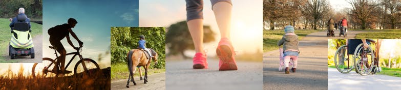
The term ‘active travel’ refers to walking and cycling, but includes other modes of travel and mobility aids.

The Council is committed to walking, cycling and wheeling as key uses of our highway network. This will support the aim of encouraging a shift away from journeys being made by private car.
(Please note that the Active Travel Hierarchy uses the term ‘wheeling’. This includes the use of wheelchairs, powered wheelchairs, mobility scooters, rollators and other mobility aids).
We also recognise the importance of our highways and public rights of way to other users. This includes those who walk, cycle or ride a horse. This could be for leisure, recreational or commercial activities. Although uses such as this are not included within the definition of ‘active travel’, we welcome input from all highway users. This will enable a wide range of needs and interests to be considered.
What is an 'Active Travel Hierarchy'?
The Council wishes to use the principles of maintenance hierarchies to support active travel. This will enable maintenance of active travel routes to be prioritised according to their importance. The ranking of routes in the Active Travel Hierarchy will be determined by measures such as:
The Active Travel Hierarchy will be about managing maintenance activities on our active travel routes. A hierarchy that helps the Council prioritise these activities will benefit all highway users. By ensuring that more important routes are maintained as a priority, users will experience better journeys. This will encourage more people to walk and cycle, which will help to reduce the amount of motor traffic on our roads. Ultimately this will contribute to reduced traffic congestion and carbon emissions.
How will maintenance standards be affected by the Active Travel Hierarchy?
Following conclusion of this consultation, the Active Travel Hierarchy will be further developed and refined. We will then assess the need to prioritise maintenance of the different routes identified in the Hierarchy against the resources available to manage our highway network. This will help to determine what maintenance standards are appropriate for different levels of the hierarchy. Your input to the consultation will therefore be valuable in helping us to understand this picture more clearly.
What maintenance standards might change?
The County Council already uses maintenance hierarchies on its road network to help determine the following:
These are the sort of maintenance activities that might be subject to change on our active travel routes and Public Rights of Way network as a part of the Active Travel Hierarchy.
How have the draft hierarchies been created so far?
The draft Walking/Wheeling and Cycling Hierarchies have been developed using a data-driven approach. The following key factors have been considered:
1. The importance of sections of highway to users. (For example, where a route links localities or important destinations like schools or workplaces)
2. The level of risk to users. (For example, where pedestrians have to share spaces with motor traffic, or a cycleway next to a high-speed road)
3. The level of use of that section. (How many people use the route).
Please note a Public Right of Way Hierarchy has not yet been developed in this way.
Why have Public Rights of Way been included in the Active Travel Hierarchy?
We recognise that Public Rights of Way (PROW) are a distinct part of the highway network. Many rural PROW present a unique opportunity for leisure journeys and wellbeing activities. The Hierarchy does not seek to change this. However, a number of Cambridgeshire's PROW do form parts of well-used active travel routes. Therefore it is appropriate to consider PROW as a constituent part of the Active Travel Hierarchy. We have deliberately categorised PROW into a standalone hierarchy. This will help ensure that their legal status and diverse character can be recognised, and so that they can be maintained suitably for their intended use.
What is the impact of the Active Travel Hierarchy on Public Rights of Way?
The Active Travel Hierarchy will not promote physical or legal changes to PROW. Changes to the surface or status of a PROW are subject to other legal and administrative processes.
By creating a PROW Hierarchy, we will be better able to identify important PROW. This will help us to consider prioritising maintenance activities accordingly. It will also give us a greater understanding of which PROW our communities and stakeholders wish to safeguard.
I am a horse-rider, how should I and other riders provide feedback?
We recognise that horses are ridden widely across our highway and public right of way network. We welcome comments from equestrian users about which routes are important to them. The majority of the routes that are shown in the Walking/Wheeling and Cycling Hierarchies form part of the road network. But they may also form be important links in riding routes. Please provide your feedback via any of the three hierarchy map layers or via our consultation survey.
I cannot see the routes I expected to see on the hierarchy maps.
The hierarchy map layers have been created to reflect the different legal classifications of highway. You may have to look on a different map layer to see some of the routes you cannot see. For example, Public Rights of Way are not shown on the Walking and Wheeling, or the Cycling hierarchies. We understand that a well-used walking route might include both a roadside footway and a Public Footpath for different parts of the route. Equally a cycle route, or a route used by horse-riders, might include some on-road sections and some stretches on a Public Bridleway.
Where this occurs, we are still keen to receive feedback. Please try to do this by using whichever hierarchy map is appropriate for the part of the route you want to tell us about. For example, to tell us about a roadside footway, use the Walking/Wheeling map. To tell us about a Public Footpath, please use the PROW map.
I cannot see a cycle route that I know to be well-used.
We are aware that in some locations, cycling takes place on Public Footpaths - often with the permission of the relevant landowner. Public Footpaths have the legal status of a Public Right of Way. We have decided to include these on the Public Rights of Way map, even if they are well-used by cyclists. You can still feedback about the importance of these routes for cyclists by using the Public Rights of Way map.
Cycling is also permitted on Public Bridleways. Public Bridleways are also classified as Public Rights of Way. Therefore these routes are also available for you to comment on using the Public Rights of Way map.
I cannot see a promoted walking route (eg, the Ouse Valley Way) - how can I comment on this?
Promoted walking routes within Cambridgeshire include the Ouse Valley Way and the Devil's Dyke Walk. Routes like these span a number of parishes and make use of many different individual PROW. We welcome your comments on these longer distance routes. However we request that feedback is given in reference to specific individual PROW, rather than for the whole of the long distance route. This is because specific sections are likely to have greater importance. For instance, a section close to a large community is likely to be busier.
PROW are referenced in our legal records by their parish and status (eg, Footpath or Bridleway). This helps us to manage and maintain the PROW network more efficiently. Feedback about specific sections will help us to better target our priorities.
I have looked on all three hierarchy map layers and still cannot see a route I wish to comment on.
The Active Travel Hierarchy maps only show public highways. Public highways are maintained by Cambridgeshire County Council as the local highway authority. The sort of routes that are not included in the Active Travel Hierarchy include:
You can still give us feedback about whether or not routes like these are important to you. Please do so by completing our Active Travel Hierarchy survey, available here. Within the survey there is an option to tell us about routes that are not shown in the hierarchy maps.
I wish to contribute to the consultation but I cannot use the hierarchy map. What can I do?
We are sorry that you are unable to use the map. We are able to make electronic (PDF) or paper maps available on request. To do this, you can write to assetdatastrategy@cambridgeshire.gov.uk. Please quote 'Active Travel Hierarchy' in your message title, and we will do our best to assist you.