Cambridge South East Transport Better Public Transport and Active Travel
Consultation has concluded
The consultation is now closed. Thanks to everyone for their feedback. The findings of the consultation can be downloaded from the project's background page.
Your views will shape the Environmental Impact Assessment for the scheme, which is planned to be submitted to Secretary of State for Transport as part of the Transport and Works Act Order Application in 2022.
As part of the planning application process we were seeking your views on the detailed design of the route proposals and how we can best manage and mitigate possible impacts on the landscape and the environment.
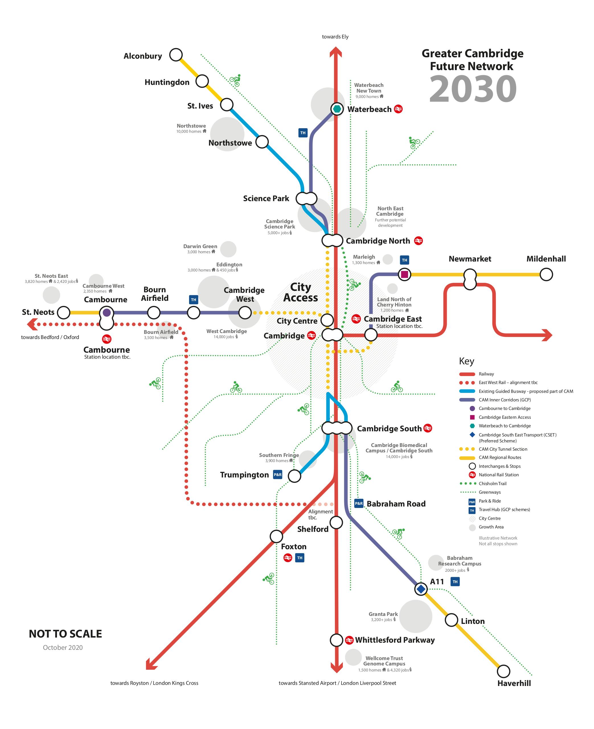
The new public transport route between the A11 at Babraham and Cambridge was approved in principle by the Greater Cambridge Partnership Executive Board in June 2020. The route would run from a new travel hub near the A11 and Babraham to the Cambridge Biomedical Campus via Sawston, Stapleford and Great Shelford connecting to the planned Cambridge South Station and existing guided busway.

You can also download the information pack in the document section on the right.
The interactive map, fly-through and video can also be found below.
Using the Map:
The map contains some highly detailed design layers, and may take some time to load.
On loading, only the route alignment layer will be enabled.
You can use the key/menu to turn layers on/off, to make it easier to find for specific information.
To view the map key/menu, click on the small icon to the left of the map title bar.
To view a full size version of the map in a new tab or window, click on the box corner icon to the far right of the map title bar.
If you find the map is slow to respond after you enable multiple layers, you may find turning some layers off again provides a better response.
You can also view the map full screen in a new tab.
Copyright - Scheme GA: ©Mott MacDonald, 2020
Introduction and Route Fly-through videos
Documents
-
 CSET EIA - Welcome (30.3 KB) (pdf)
-
CSET EIA - What is CSET (2.09 MB) (pdf)
-
CSET EIA - About this consultation (29.3 KB) (pdf)
-
CSET EIA - Individual Scheme Elements (15.3 MB) (pdf)
-
CSET EIA - Environmental information by area (10.9 MB) (pdf)
-
CSET EIA - CSET EIA - Find out more (39.9 KB) (pdf)
-
CSET EIA - Printed Questionnaire (7.07 MB) (pdf)
-
CSET EIA - Map (2.63 MB) (pdf)

Images and Photos
Videos
-
 A CGI flythrough of the CSET Better Public Transport project route, showing detail of key locations and designs.
-
 An introduction to the Environmental Impact Assesment consultation, by Jane Osayimwen