Cambridge South East Transport - Better Public Transport Project
Consultation has concluded
The findings of our public consultation on a new travel hub near the A11/A1307/A505, a new public transport route between the A11 and the Cambridge Biomedical Campus, and new walking, cycling and horse riding links have now been analysed.
The key findings include:
Over half of respondents (56%) indicated they support the more detailed proposals presented for consultation.

The response for each of the three travel hub locations was as follows:
- 46% of respondents supported ‘Site B’ with 30% opposing it
- 37% supported ‘Site A’ with 37% opposing it
- 44% opposed ‘Site C’ and 30 % supported it

There was no majority of support for any of the five routes for accessing the Travel Hub sites:
- Respondents were not clear on their support for the ‘Purple route (Site A)’, ‘Pink route (Site B)’, or ‘Brown route (Site B)’
- Respondents were opposed to both ‘Site C’ routes (‘Black’ and ‘Blue’ routes)

The detailed findings of the public consultation can be viewed in the document section on the right and will be presented to the Joint Assembly on 4 June and the Executive Board on 25 June. More information and papers on these meetings can be found on the Joint Assembly meeting page and the Executive Board meeting page.
2019 Public Consultation
The Cambridge South East – Better Public Transport project is a priority for the Greater Cambridge Partnership (GCP), creating a vital link to ease congestion, offer sustainable travel choices, connect communities and support growth. It would form part of the Cambridgeshire Autonomous Metro, providing high-quality, frequent and affordable public transport.
The project provides better public transport and sustainable options for those who travel in the A1307 and A1301 area, improving journey times and linking communities and employment sites in the area south east of Cambridge and beyond.
BACKGROUND INFORMATION
The proposed new public transport route would link the Cambridge Biomedical Campus via Great Shelford, Stapleford and Sawston to a new travel hub near the A11/A1307/A505 with connections to Babraham, the Babraham Research Campus and Granta Park.
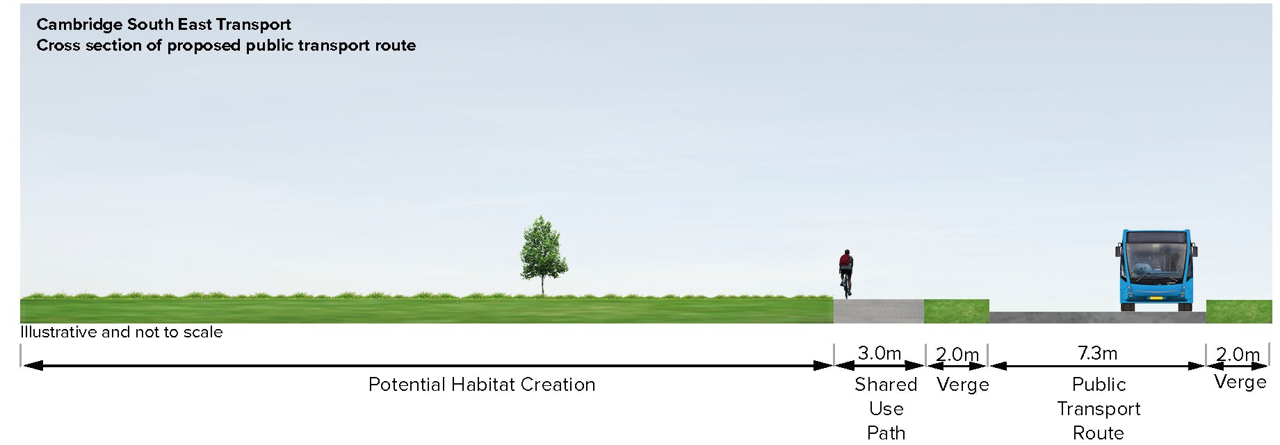
The route would be entirely off-road, only interacting with other traffic at junctions. Junctions between existing roads and the new public transport route would be controlled by traffic lights.

Proposed Route
At the Cambridge Biomedical Campus the route is proposed to run on prioritized public transport lanes on Francis Crick Avenue, connecting to the existing Busway and enabling services to continue to the station and Cambridge city centre via the Busway.
A new shared-use path for walkers, cyclists and horse riders, generally 3 metres wide, would be built alongside the new public transport route.
We were asking for your views on the proposed alternative options to the east of Sawston linking to three potential locations for a new travel hub site near the A11/A1307/A505.

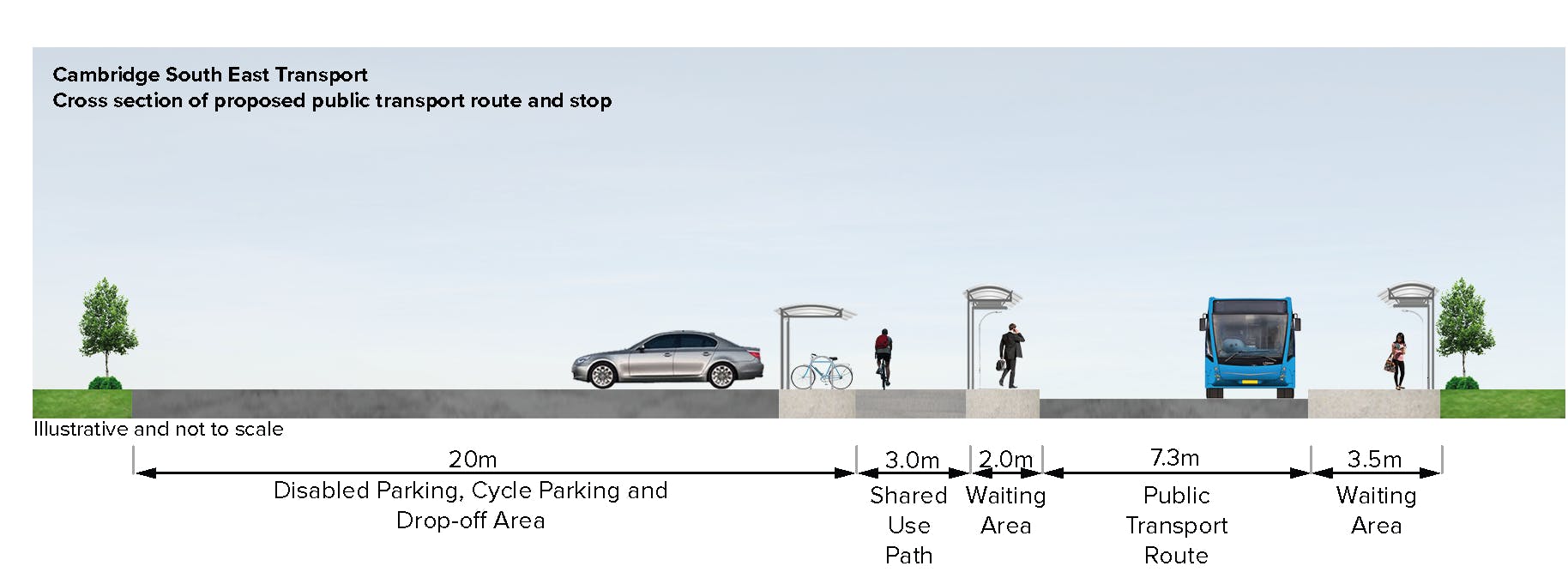
Typical cross section of proposed public transport route and stop

Typical cross section of proposed public transport route
BUS JOURNEY TIMES & RELIABILITY
| Current bus journey times* | |
|---|---|
| Route | Journey Time |
| Sawston to Cambridge | 43 to 53 minutes |
| Sawston to Cambridge Biomedical Campus | 23 to 33 minutes |
*Citi 7 scheduled inbound journey times from Sawston, Link Road to Addenbrooke’s bus station and Emmanuel Street.
| Estimated future journey times* | |
|---|---|
| Route | Journey Time |
| Sawston to Cambridge | 30 to 32 minutes |
| Sawston to Cambridge Biomedical Campus | 10 to 12 minutes |
*Estimated journey times are calculated between proposed public transport stops. Further measures to reduce congestion in Cambridge would lead to even quicker journey times.
| Journey reliability |
The proposals would offer more reliable journey times, avoiding congestion on roads.
COSTS
Estimated cost
£110 - £155 million.
Costs may vary depending on combination of route and travel hub option.
Why is there only one main route option?
Other options for the route between the Cambridge Biomedical Campus, Sawston and the travel hub locations have been considered and were assessed. These included variations of an off-road route as well as options on or alongside the A1307. These options were consulted on in 2018 and the results of that consultation showed strong support for the proposed off-road solution. These proposals presented here for consultation are on the more detailed route proposals, alternatives for crossing the A11 and proposed travel hub sites.
An alternative route alignment running through the centre of villages or following the old railway alignment south of Stapleford was not found to be feasible because of space constraints in Great Shelford and the greater impacts on residential properties and businesses. It would also be significantly more expensive and disruptive during construction given its closeness to the mainline railway. For more information on this, please see report in the document section on the right.
STOPS ALONG THE ROUTE
The image below shows the typical layout of a stop along the proposed public transport route. Stops would have:
- platforms with shelter and real-time passenger information
- drop-off facilities
- disabled parking
- cycle parking and cycle lockers
Locations of stops are proposed on Babraham Road in Sawston, Haverhill Road in Stapleford, Hinton Way for Shelford and near the Busway bridge on the Cambridge Biomedical Campus.
The proposals have been developed to ensure stops are as close to villages as possible, whilst trying to limit the impact on the environment, for example avoiding hedgerows. Connections to the stops will be improved and integration with existing bus services enhanced as far as possible.

TRAVEL HUB OPTIONS
There are three options for the travel hub location:
- Site A – west of the A11 and north of the route of the old Cambridge - Haverhill railway with access from the A505.
- Site B – between Babraham and the A11 with access from the A1307
- Site C – north of Little Abington, with access from the A1307 opposite the existing Four Went Ways service station junction
There are two options for the public transport route between Sawston and each of the travel hub sites B and C and one option for the public transport route to site A.
All sites proposed in this consultation would have a minimum of 2,000 car and 200 cycle parking spaces.
Our proposed travel hub would be as sustainable as possible and use renewable energy as much as possible. It would provide for future expansion, if needed.
The use of brownfields sites, such as at Newmarket Road, was considered. However, they do not provide the desired capacity for parking spaces without relocating the existing hotel, filling station and fast food outlets, which would be very costly. For more details on this, please see the review of brownfield sites report in the document section on the right
We were asking for your views on these travel hub locations, the public transport route options to serve them and the initial proposals for site layouts, facilities and access arrangements for road vehicles, pedestrians and cyclists.

Travel Hub site A (Site A plan)
- Traffic from the A1307 would have to divert onto the A11/A505 to reach the site
- Road access to the site via an access road from an improved junction on the A505
- Site constrained by high-pressure gas main to the east and the River Granta to the north
- Located close to Granta Park but less convenient for Babraham Research Campus
- Located in green belt
Travel Hub site B (Site B plan)
- On the direct route into Cambridge from the A1307 and A11
- Road access to the site via a new junction on the A1307
- Site constrained by high-pressure gas main to the west and the River Granta to the south
- Located midway between Granta Park and Babraham Research Campus, with potential for good pedestrian and cycle links between the travel hub and both campuses
- Located in green belt
Travel Hub site C (Site C plan)
- On the direct route for traffic from Haverhill to Cambridge, but traffic approaching from the A11 would have to divert away from Cambridge to reach the site
- Road access to the site by replacing the existing junction between the A1307 and Newmarket Road with a four-arm roundabout
- Located further from Babraham Research Campus and Granta Park and less accessible
- Additional stop near Babraham to allow for easier access to the Babraham Research Campus and Granta Park
- Located outside green belt
- Close to Little Abington
- Requires new bridge over the A11, which would be more expensive
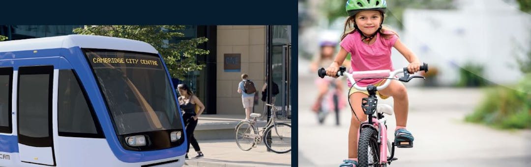
Autonomous Shuttle Service
Cambridge is on track to be one of the first cities in the UK to have a groundbreaking autonomous shuttle service as part of its public transport network.
Initial out-of-hours trials between Trumpington Park & Ride and Cambridge Station (via the Cambridge Biomedical Campus) are planned over the next twelve months. If successful, the service could then be rolled out elsewhere around Greater Cambridge to link some of the science and business campuses to each other or to travel hubs.
This could include Granta Park and Babraham Research Campus.
In the meantime, it is possible that some services will not terminate at the travel hub, but would carry on to Babraham Research Campus and Granta Park.
CAMBRIDGESHIRE AUTONOMOUS METRO (CAM)
The Cambridgeshire and Peterborough Combined Authority’s plans for a wider, regional CAM are at an early stage and action is needed now to tackle worsening congestion and accommodate housing and employment growth. A future CAM network proposes electric, rubber-tyred tram-like vehicles using dedicated, off-road routes to bypass congestion.
The proposals presented in this leaflet are part of the emerging CAM, which would extend underground through Cambridge to provide traffic-free, fast transport. The proposals here are the first phase of CAM, with ambitions to extend CAM to Haverhill in the future. GCP will continue to work closely with the Combined Authority as proposals for the CAM develop.
ENVIRONMENT, POTENTIAL IMPACT AND ENHANCEMENTS
Landscape: There would be an impact on the green belt. The design of the final scheme would ensure it is integrated into the existing landscape as much as possible to minimise the impact.
Please see indicative landscaping proposals in the Document Library on the right for more details.
Environment: Some sections of the proposed route would provide opportunities for creating linear parks. In these, shared-use paths would be integrated with environmental mitigation to create more pleasant areas. Options for improving biodiversity through the scheme design will look into opportunities to connect existing habitats along the route with appropriate planting.
Please see indicative landscaping proposals in the Document Library on the right for more details.
Biodiversity: GCP is committed to ensuring the scheme delivers a minimum of 10% biodiversity net gain with a target of at least 20%. This would be achieved by designing a scheme that incorporates new habitats that are connected, where practical, with existing habitats and increase the potential biodiversity of species along the route and around the potential travel hub. GCP is committed to preserving the Old Railway County Wildlife site.
Nine Wells Nature Reserve: The scheme would create opportunities to enhance the setting of the Nine Wells Nature Reserve and improve access by better signposts and links with shared-use paths. The route past Nine Wells Nature Reserve provides an opportunity to buy the land immediately next to the reserve up to the existing shared-use path. This area could be returned to a more natural state that complemented the habitat in the nature reserve.
River crossings: The proposed routes involve up to two crossings of the River Granta which would be sympathetically designed with full consideration for landscape and habitat. The new crossings would not increase flood risk in the area.
Heritage: The proposals being consulted on have been selected to avoid direct effects on the important Wandlebury and Gog Magog Hills area and avoid going through any conservation areas.
Noise: The use of electric vehicles is proposed which would reduce noise impacts along the route. As the design develops noise impacts would be assessed and suitably landscaped noise barriers included where required.
Air quality: There is potential for an improvement in air quality in Cambridge and surrounding areas if quicker, more reliable and more frequent public transport services encourage more people to use public transport rather than private cars. The use of electric vehicles would also improve air quality.
Construction: The majority of construction would be
off-road. There would be some disruption at junctions and side roads. All construction impacts would be assessed and minimised through robust management plans, which would be promoted locally.
The GCP is continuing to meet with local and environmental representatives to work on the details of any potential enhancements and to lessen impacts of the proposals where possible.
WHAT HAS HAPPENED SO FAR?
Following initial public consultation in 2016, and developing further options with community representatives in 2017,
a consultation in 2018 put forward shorter-term proposals and three longer-term strategies.
The shorter-term proposals included bus priority, walking and cycling measures and road safety improvements along the A1307 between Haverhill and Cambridge. The 17 elements of these proposals were supported by the public and construction is underway.
More information on these is available at www.greatercambridge.org.uk/A1307
Strategy 1, a new segregated public transport route between the A11 and the Cambridge Biomedical Campus was, for 64% of respondents, the most strongly supported of the three strategies at last year's consultation.
Strategy 1 also had the highest percentage of respondents who felt it would encourage them to switch transport mode away from the car.
NEXT STEPS*
- Early 2020: Consultation results and route presented to GCP Executive Board for decision on preferred option and to prepare for the application for powers to build the scheme
- 2020-2022: Statutory consents process - Obtaining the powers to construct the scheme and further work including environmental impact assessment
- 2022: Start of Work
- 2024: Scheme completion
*Timescales are indicative and dependent on approvals.
Contact us
If you would like to get in touch to discuss the project in more detail, please contact us:
Via phone 01223 699906
Via email consultations@greatercambridge.org.uk
Facebook www.facebook.com/GreaterCam
Twitter www.twitter.com/GreaterCambs
You can read more about the Cambridge South East project on our website.